Martin Ludgate reports the opening of a short but significant length of canal on the edge of Lichfield – and how it fits in with plans to reopen the rest of the route.
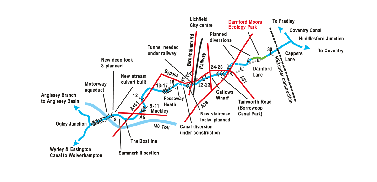
It’s a blustery spring day and a large group of people have gathered by a stretch of water alongside a golf course on the southeastern outskirts of Lichfield to celebrate the completion of something called Darnford Moors Ecology Park. Well, that’s what it’s called, but one could be forgiven for thinking that it looks remarkably like a section of newly completed canal…
And that is, indeed, what it is. It’s a 600-metre length of the Lichfield Canal, and the Lichfield & Hatherton Canals Restoration Trust is hosting the official opening. But as Trust Chair Carole ??? makes it clear, it’s about a lot more than reopening a canal, it’s “a superb example of what can be done when people work together”, and it’s happened because it’s providing all sorts of other more immediate benefits (such as wildlife improvements and community resources) besides future navigation from the Coventry Canal to the Birmingham Canal Navigations. This in turn has enabled it to benefit from various sources of funding. But first let’s look at what’s actually been happening in the last couple of years…
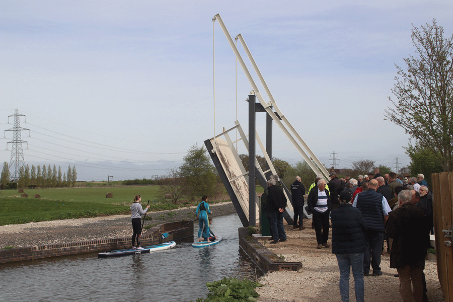
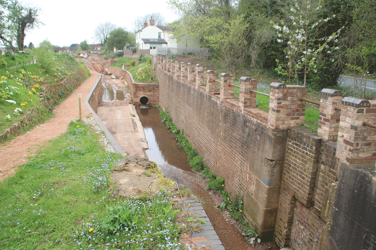
In autumn 2022, following the announcement of the first package of funding, the Trust was able to make improvements to the Darnford Brook wetlands (an area alongside the brook which passes under the canal in a culvert), to existing woodland and hedgerows running alongside the canal, and to the canal channel itself on the east side of the Darnford Lift Bridge which is a prominent feature of the section of canal.
The work included the Trust’s volunteers clearing brambles and other undergrowth from the canal bed, using excavators to reprofile the channel, re-securing piling which formed one bank of the channel, as well as work on the wetlands and an associated nature trail.
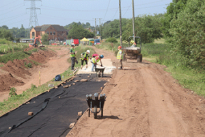
This was followed in spring 2023 by the arrival of contractors Onsite Central Ltd to carry out the main work to line the canal channel (it runs through particularly porous sandy soil in this area). The lining method used a matting material consisting of waterproof bentonite clay sandwiched between woven textile layers, which was then covered over with soil, followed by a layer of grid matting and gravel.
Further funding confirmed in April 2023 allowed Onsite Central to continue on to the second phase of the work, to the west of the lift bridge, where the canal channel leaves the original route (you can still see the remains of the old Lock 29 on the old line), and follows the beginning of a diversion which in the future will make it easier for the canal to cross Darnford Lane and get closer to Lichfield. By autumn 2023 the entire 600 metre length to just short of Darnford Lane was being filled with water.
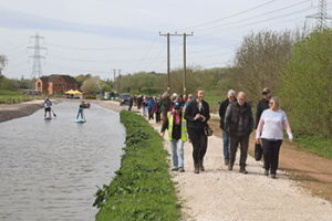
The newly completed length at Darnford
Visiting WRG volunteers working on the same site less than a year ago
Meanwhile, LHCRT’s volunteers, supported by visiting teams including Waterway Recovery Group Canal Camps and working weekends, laid the towpath. With a view to the future, this included installing equipment to enable charging points to be provided for electric boats.
At the same time, work on nature habitats alongside the canal included not just the wetland area already mentioned (which has been designed to capture winter flood water and stay wet all year) but planting 80 new trees (of species selected for reasons involving pollen, fruit and carbon capture), new hedging (involving work by Duke of Edinburgh’s Award and Green Team volunteers), planting wildflowers including native bluebells, creating ‘bug hotels’ from dead wood. The good news is that not only have mallard ducks taken up residence, but a little egret has been seen too.
Back to the official opening, and there were speeches from the major funders of the project – and the variety of sources shows what Carole meant by ‘working together’. The main grant that has paid for the work has come from Biffa Awards, a scheme run by the Biffa waste company to provide grants to community and environmental projects near its landfill sites. Their representative made it clear that what had swayed Biffa in favour of supporting the application was the vision of the people involved, and the volunteer effort which had already got it to the stage where the funding bid was submitted. Further funding has come from the European Regional Development Fund, as well as the Wesleyan Fund, a local organisation in Birmingham who provided a climate action grant, highlighted the canal’s role in such things as flood alleviation. And perhaps surprisingly there was a contribution from HS2 – yes, the company building the controversial high speed railway. Through its Community and Environment Fund HS2 is giving grants to areas affected by the new line – and that certainly applies to the Lichfield Canal…
At the east end of the Darnford length, the canal currently comes to an abrupt stop at a temporary dam. But just a few hundred yards further east is a major building site where the spur of HS2 linking the London-Birmingham route to the existing West Coast Main Line cuts across the canal.
The bad news, is that construction of the railway will involve the demolition of Cappers Lane Bridge, a new structure created some 20 years ago to carry the restored canal under an existing road, and which has never seen a boat. The better news is that as remediation for its impact on the canal, HS2 will be providing a new Lichfield Canal diversion channel and associated structures. In combination with relocation of the Lichfield Boat Club moorings (the Club restored the easternmost length of the canal where it meets the Coventry Canal many years ago to create these moorings) this will create the first length of the restored Lichfield Canal.
And the short intervening length between there and the Darnford Moors site, which includes Lock 30, is now also owned by HS2 Ltd and will be able to be restored (the exact timing is uncertain, as work on this section of the railway has been delayed by two years), opening up navigation from the Coventry Canal to Darnford Lane.
Going back to the opening speeches again, there were a few words from John Horton of LHCRT, who was involved in the earliest works in the Darnford area, at the end of the 1990s.
That date might raise some eyebrows. Quarter of a century sounds like a very long time to restore 600 metres of canal. Even for a short canal like the Lichfield, that rate of progress would mean that completion would be hundreds of years into the future! But as John explains, it’s not that simple…
We’ve already mentioned some of the products of the work carried out back in those early days. The culvert carrying the brook under the canal was rebuilt in concrete by volunteers; the abutments for the lift bridge – a gift from the Peak Forest Canal where it was no longer needed – were also built by volunteers; they also installed the steel piling forming the canal bank on the towpath side. A route for the canal to be diverted to facilitate crossing Darnford Lane was identified, the land was acquired, and the channel was dug. All this went well; indeed, John Horton reckons it not only contributed to the eventual reopening of the canal, but the quality of the work established the Trust’s credibility with local authorities who hadn’t initially been very supportive – some councillors had been around since the days when the canal was closed and parts of it filled in, and couldn’t at first see much of a future for it.
But what went less well was the first attempt to line the canal with bentonite matting and re-water a trial length. It proved impossible to make it watertight.
Faced with this problem, LHCRT shifted its attention to another site, at Tamworth Road on the southwest side of Lichfield, which has taken up much of the Trust’s effort over the intervening years. You can see what’s been done there for yourself – a towpath trail has been created as part of the work. And beyond, you can walk through to the Gallows Wharf and Fosseway work sites which have also seen plenty of restoration progress more recently. But before we go there, let’s mention a couple of other features on the way there…
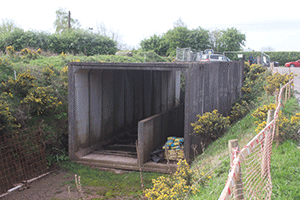
Concrete culvert sections ready for Darnford Lane bridge construction
The first is Darnford Lane Bridge. Here, a new bridge will be needed to take the road over the diverted canal – but the good news is that several concrete box culvert sections (complete with towpath section) are already lined up there ready to be installed. They were left over from another project some years ago, and are waiting for their time to come – which might be within the next few years.
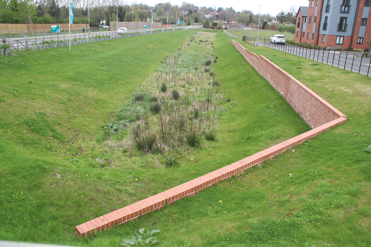
The following section is subject to landowner discussions, but it’s possible to take a footpath from Darnford Lane through Darnford Park to where there are signs of some some sizeable holes in the ground in a quiet corner of the park. These were initial excavations several years ago to create part of the route where the restored canal will one day deal with probably its most serious obstruction – it needs new bridges to cross under the A38 and A51 main roads, linked together by a pair of new locks in the park. LHCRT’s engineer Peter Buck admits that it’s “the big one” and that some serious funding will need to be found, but says the Trust is putting together plans for it.
The former Lock 24 at Tamworth Road, being converted into a retaining wall for a cutting
Immediately the far side of the A51, the canal reappears – and this is the start of the Tamworth Road section and its associated Towpath Trail. But as John Horton explains, the decision to shift work here in the early 2000s didn’t mean the Darnford section was completely forgotten. In fact, some stone from the old lock 29 was brought here to help with the lock restoration work, while some spoil excavated from Tamworth Road was taken to Darnford to build up the canal banks.
The towpath follows a completed length of canal as it turns right to join the original line and climbs through two locks (restored apart from gates). There used to be a third lock beyond, but it’s in the process of being abolished: the next section of canal is being lowered, to enable it to pass under another road (Cricket Lane) and a new lock on the other side of the road will be built to return the canal to the correct level. That sounds like a lot of work, but housing developer Persimmon Homes is to build the new bridge, and the work to remove parts of the old lock (and rebuild the rest of it as retaining walls alongside the channel) is well on the way to completion by LHCRT’s volunteers.
Not far beyond Cricket Lane is the next section that LHCRT have been working on. A good length of rebuilt towpath wall leads to Gallows Wharf, and a surviving bridge carrying a main road over the canal.
Partly completed length alongside the Lichfield Bypass
On the other side, the Lichfield Bypass road comes alongside the canal on the right – and the construction of this road over the past 15 years or so has had both positive and negative impacts on the canal. On the plus side, a strip of land (at one point barely wide enough) has been reserved alongside the bypass for the canal (part of it is on the original route, part is another planned canal diversion) and some of the necessary bridges will be provided by developers. On the minus side, this didn’t go as far as providing a bridge to take the canal under the Lichfield to Birmingham railway line.
Towards the end of the section alongside the bypass, the new canal has been created as a brick sided channel, and takes a sharp left turn as it leaves the road behind and heads out of Lichfield on its original route. This is the Fosseway Heath work site – and was the scene of LHCRT and WRG work several years ago to recreate the canal channel and towpath wall. Once again it was done both as a nature reserve and canal restoration project, incorporating land on either side of the canal and attracting funding grants that probably wouldn’t have been available for a straightforward canal reopening scheme.
It leads to Lock 18, restored over 30 years ago as one of LHCRT’s earliest projects; recently the volunteers have returned to spruce it up and to reinstate the channel beyond to where Fosseway Lane crosses the canal.
This is where we’ll end our walk up the canal for now. It’s barely halfway up the six mile length, but the next sections aren’t publicly accessible yet.
We will, however, mention one final project a couple of miles further on – and John Horton reckons it’s another place where the credibility gained by the early work at Darnford Lane has helped. Some 20-plus years ago the M6 Toll motorway was being planned, and would need to cross the canal. The local geography indicated that an aqueduct would be more practical than a navigable culvert, but the road builders (and the Government) were not under any obligation to make any provision for navigation, and would do nothing beyond providing foundation bases for the structure.
Thanks to a Manifold Trust grant of £250,000 and a successful funding appeal (fronted by LHCRT patron, canal supporter and well-known actor David Suchet) sufficient funding that the aqueduct could be built at the same time as the motorway.
It stands there today looking slightly incongruous with no canal at either end of it. But it’s a tribute to the success of LHCRT in getting a difficult canal restoration project taken seriously, in the face of challenges including both the M6 Toll and HS2.
Lichfield and Hatherton Canals
The Lichfield and Hatherton Canals Restoration Trust aims to reopen two short but important links which would connect the underused northern parts of the Birmingham Canal Navigations network to the rest of the Midlands canal system.
The Lichfield Canal is the canal restorers’ name for the abandoned eastern end of the Wyrley & Essington Canal. Today, the W&E runs from Wolverhampton (where it joins the BCN Main Line) to the former Ogley Junction where it leads to the Anglesey Branch. But originally it continued for another six miles beyond Ogley, descending through 30 locks via Lichfield to meet the Coventry Canal at Huddlesford. This final section was abandoned in the 1950s but LHCRT is working to reopen it.
The Hatherton Canal is the name given by LHCRT to a route from the Staffordshire & Worcestershire Canal at Hatherton Junction near Calf Heath to the Wyrley & Essington Canal. The original route, abandoned in the 1950s, ran via the Hatherton Branch of the S&W, the Churchbridge Locks Branch, and the disused part of the Cannock Extension Canal north of Norton Canes. However, the loss of parts of this route to opencast mining mean that a restored canal would take a different route at its eastern end.
Although LHCRT has worked on both canals, the Hatherton has taken a back seat in recent years while work has mainly concentrated on the Lichfield..
 As featured in the June 2024 issue of Canal Boat. Buy the issue here