In the first part of our guide to this popular Midlands cruising circuit, we follow the northern Grand Union Canal from Napton into Birmingham, then return to the countryside via the Birmingham & Fazeley Canal.
Words and Pictures by Martin Ludgate
I can’t help thinking that perhaps there’s something perverse about starting a journey around the popular and varied circuit of Midlands canals known as the Warwickshire Ring at one of the few places on that ring that isn’t actually in the traditional county of Warwickshire.
So rather than begin at Braunston, the Northamptonshire canal village at the heart of the South Midlands waterways network, we’ll begin five miles west of there at Napton Junction. It might not have quite the same status in waterways circles (although both of them share the distinction of being meeting points of two great long-distance through routes, the Oxford Canal and the Grand Union Canal) but it’s in the right county, and from a practical point of view it’s surrounded by marinas and hireboat bases and therefore a starting point for plenty of cruises around the Ring.
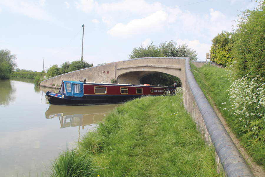
Historically, it was the Oxford Canal which arrived here first around 1774 (it took another 15 years to get through to Oxford), followed a couple of decades later by the Warwick & Napton Canal – part of today’s Grand Union Canal – which joined the Oxford at Napton Junction. Our journey begins as we turn off the Oxford Canal under a 1930s concrete towpath bridge onto this newer waterway, opened in 1793 as part of a plan to provide a shorter route to Birmingham.
Into the Avon Valley
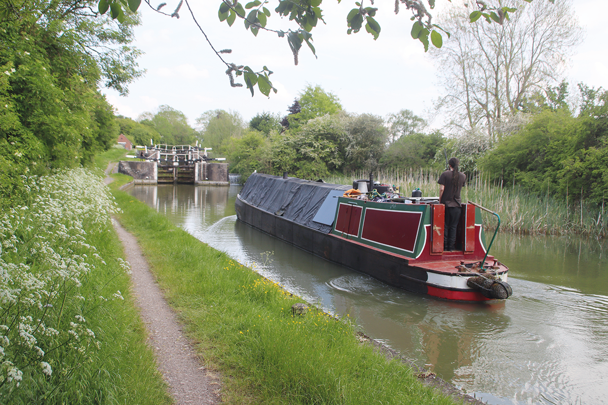
Marinas and moorings surround the canal as it heads due north to reach the first of a long series of locks descending into the Avon Valley. Rebuilt to 14ft wide beam in the 1930s (following the takeovers which created the Grand Union Canal from its former constituent companies – see our Cruise Guide Extra on the following pages for the full story), they’re filled and emptied using distinctive enclosed worm-driven paddle gear, not found elsewhere on the waterways. They aren’t (usually) too stiff to open, but they do take a lot of turns – up to 25 in some cases. And although (unlike almost all other paddles) they’re designed to be closed by simply knocking off the catch and allowing them to fall (the worm gearing lets them drop at a controlled speed), you’ll need to make sure they’ve completely closed as they can stick not quite fully shut.
You’ll also notice that the locks fill and empty very quickly: if you aren’t in a hurry (and who is, on the canals?) and you aren’t holding anyone up, you can save half the work by only using one paddle – it really doesn’t take that much longer.
More marinas follow as the canal turns north westwards, running through quiet countryside to reach Birdingbury with its handy pub (something of a feature of this length), followed by the next flight of locks.
Ten locks continue the descent, and they make an impressive sight – although they’re rather outclassed by what’s to come in a few miles. They take the canal down into Long Itchington, where another waterside pub is followed by a boatyard specialising in historic working craft – and then by not one but two pubs facing each other across the water. Long Itchington village is a short walk to the north, with shops and… you guessed it… several more pubs!
After a short break, the locks begin again with a Grand Union rarity – a pair of staircase locks, which form the first two of a flight of four at Bascote. They were equipped with water-saving side-ponds too (presumably to make up for the fact that staircase locks tend to use more water than singles), which would have made operation rather more complicated – but they’ve long been out of use.
Grand Union rarity: a pair of staircase locks at Bascote
In the past, I might have described the canal’s surroundings as quiet, rather empty countryside – but right now it’s neither empty nor quiet, as the peace has been disturbed bv the linear construction site that is the new HS2 high speed railway. The line will cross the canal on a concrete viaduct a little way beyond Bascote.
As the new railway makes its presence felt, a couple of much older transport routes are recalled in the names of the nearby locks. Welsh Road Lock is named after one of the old drovers’ roads which were used to take livestock from farms in Wales to the markets in London, until the arrival of the railways brought an end to droving. And just beyond, the name of the three Fosse Locks goes back even further, to the old Roman road the Fosse Way which ran from Exeter to Lincoln, and crosses the canal between the locks. Radford Bottom Lock finally marks the end of the descent after 23 locks altogether.
Leamington and Warwick
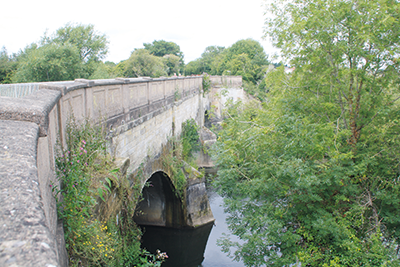
A three-arch aqueduct carries the Grand Union over the River Avon
The ‘bottom pound’ (or ‘trough pound’ – there doesn’t seem to be such a standard name for the opposite of a ‘summit level’) continues for five level miles as the canal passes first through Leamington Spa, and then through Warwick. Both towns are well worth visiting, with Leamington’s Regency architecture and shopping, while Warwick has its famous castle.
The built-up areas of the two towns almost meet, but there are a brief few hundred yards of rural canal between them, including a three-arch sandstone-built aqueduct crossing the River Avon.
An industrial area follows, as the canal passes to the north of Warwick town centre (reachable easily by a half-mile walk from Bridge 49), and then it isn’t far before the two Cape Locks (they take their name from the Cape of Good Hope canalside pub) begin the climb out of the valley
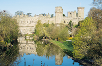 Warwick Castle
Built in the 12th century, it was a stronghold for 500 years before being converted into a mansion which was home to the Earls of Warwick. Since the 1960s, it has been run as a tourist attraction with apartments featuring waxwork figures of historic characters, a display of armour rated second only to the Tower of London, archery, jousting and other displays, and the world’s largest working siege engine
A steep climb
Yes, that’s right: having descended through 23 wide locks from Napton, after just five miles’ rest, we’re going to climb back up through another 23 locks on the other side of the Avon. And yes, the canal builders recognised how much of an impediment to through traffic this was, and tried to come up with alternative routes which would have crossed the Avon further upstream and need fewer locks. In 1827, there were proposals for a London & Birmingham Junction Canal, which would have linked the summit level of the Stratford-upon-Avon Canal (on the same level as the centre of Birmingham) to Braunston (where it would have met the Grand Junction Canal, today’s southern Grand Union leading to London): it would have needed just 20 locks, compared to 65 on the existing route. Opposition from the existing canal companies, whose routes it would bypass, ensured that it didn’t get built.
It might come as a surprise, just a little way after Cape Locks, to arrive at a T-junction and need to take a right turn to continue on the route. This is another relic from pre-Grand Union days: here the original Warwick & Napton Canal ended, as it met the Warwick & Birmingham Canal. Although the two ‘Warwick canals’ were very much seen as forming a single through route, and built simultaneously (both begun in 1793, both finished 1799), they kept their own identity and the Warwick & Birmingham had its own terminus in Warwick.
Turning left at the T-junction (do check first!) takes you into what’s left of that original terminus (the final length has been cut off by a demolished railway bridge), which has been restored as the Saltisford Arm by Saltisford Canal Trust, which operates a visitor centre, shop and moorings. Turning right at the T-junction continues the through route, and leads very soon to Hatton Locks.
Other than the flight of ten locks at Stockton, the descent into the Avon Valley was relatively gentle, being spread out over eight miles or so. The climb back out of the valley is anything but: the remaining 21 are combined in a single flight here at Hatton, and once you get into ‘the thick’ of the flight, they make an impressive (if perhaps a little daunting) sight as they march up the hill ahead.
They’re quick to fill, so you won’t get much rest. But look out for the rather unfortunately named Ugly Bridge (is it fair?) after the sixth lock, the historic canal maintenance yard buildings (now Canal & River Trust offices) on the left near the top of the flight, and views behind you back to Warwick Parish Church. And encourage yourself with the thought that there’s a handy pub not far from the top lock – and you won’t need to get your windlass out again for another eight miles.
A unique tunnel
That’s not to say that the next length is devoid of navigation interest, though: one of the canal system’s more intriguing features follows in less than two miles…
Approaching it from the south west as we are doing, Shrewley Tunnel looks much like many other tunnels. It was built without a towpath, so boats were ‘legged’ through, while the horses were led over the top via a tunnel path which can be seen climbing to the left of the portal. But at the far end, the tunnel path passes through its own separate short tunnel just above and to one side of the main canal tunnel.
Rowington and Lapworth follow; at the latter a short arm leads off on the left, forming a connection to the Stratford-upon-Avon Canal: turn left for Stratford, or right for an alternative route to Birmingham.
Onto the Ten Mile Pound
We’re now onto a less well-used part of the Grand Union Canal, running through quiet countryside to reach Knowle Locks, the final set of wide locks dating from the 1930s modernisation. They replaced a set of six narrow locks, and are slightly deeper and harder work as a result – but they’re followed by the ‘ten-mile pound’ which is exactly what it sounds like, and leads all the way into Birmingham. The northernmost of the Grand Union Main Line’s three summit levels begins with attractive rural meanderings past Catherine de Barnes village, but then settles down to the long series of deep, straight, largely tree-lined cuttings by which it maintains the lock-free level as it enters Birmingham’s suburbs – although you wouldn’t necessarily know it, as the surroundings are often hidden from view. Bridges old and new span the cuttings as the canal passes Solihull, Olton and Yardley, while the odd short embankment reveals that we’re passing extensive housing estates.
Knowle Top Lock and the start of the Ten Mile Pound
These give way to industry as the canal approaches the city centre, while towpath bridges span former arms which once served local industries – it was the canals’ ability to connect directly to so many industrial premises that kept local freight traffic busy on the canals of Birmingham and the Black Country when it was already in decline elsewhere. One such arm at Tyseley is now home to The Ackers water sport and leisure facility.
Into industrial Birmingham

The former Sampson Road Depot, where boats from London once unloaded
A long line of industrial buildings on the left lead to the loading canopies which mark the site of Sampson Road Depot, which was the Birmingham base for the Grand Union Canal Carrying Company’s fleet, and the destination of a lot of the long-distance freight from London in GU days.
This is where the Ten Mile Pound comes to an end as the six Camp Hill Locks lead down to Bordesley – and you will notice immediately that they’re narrow-beam: the lock rebuilding programme of the 1930s didn’t extend this far. The locks are surrounded by roads and railway lines, and a road improvement scheme of 30-plus years ago led to the canal being diverted via a replacement lock and a couple of awkward bends.
Below the sixth lock is Bordesley Junction. Here the final length of the former Warwick & Birmingham Canal bears slightly to the left and heads for Warwick Bar, the Digbeth Branch of the Birmingham & Fazeley Canal, and Farmers Bridge Locks climbing through Birmingham city centre. But we’ll take a right turn, under a traditional cast iron towpath bridge (which seems to attract more than its share of graffiti) and onto another new canal – the Birmingham & Warwick Junction Canal, otherwise known as the Saltley Cut.
 See Also – Thinktank
Not far from the canal at Bordesley or Aston is Birmingham’s new science museum and family attraction. It includes a planetarium, science garden, Spitfire gallery, historic transport collection and the ‘Power it’ display featuring the world’s oldest working steam engine
A relative latecomer opened in 1844, this short canal was promoted and funded jointly by the Warwick & Napton and Warwick & Birmingham companies. They were worried that the Tame Valley Canal, under construction at the time, would create a short-cut that would put their route at a disadvantage for London to Birmingham trade compared to the alternative route via the Birmingham & Fazeley, Coventry and North Oxford canals. So, this two-mile canal was their own short-cut aimed at keeping their route competitive.
As befits a ‘modern’ 1840s canal, it begins with a dead-straight length (you can see straight through the first five or six bridges) before passing right underneath a factory building. Assorted railway lines cross over it at various levels as it descends the five rather unkempt Garrison Locks amid industrial surroundings – and they’re about to be joined by more railway lines…
A recent visit to photograph the canal for this article revealed the unexpected sight of a set of traffic lights controlling boat movement – which turned out to be the result of a temporary narrowing of the channel during the construction of the Birmingham spur of HS2, which will cross the canal on its approach to the city terminus station. Having not seen a boat moving in ten miles since Solihull, I couldn’t help wondering if it was really worth the cost of providing this level of traffic control. And then four boats arrived!
The final length of the Saltley Cut was once industrial too, but in recent years it’s become positively leafy, while an entertainments complex accompanies the canal on the approach to Salford Junction, where we meet the Birmingham & Fazeley Canal. A shallow stop-lock once kept the two companies’ waters separate, but for many years it’s been gateless and boats cruise straight through.
Climbing Garrison Locks surrounded by industry, power lines and railway tracks
A complex junction
The junction is a complicated affair, rather overshadowed by being situated directly underneath the Gravelly Hill motorway interchange – better known as ‘Spaghetti Junction’. How many drivers would guess that there’s a four-way canal interchange underneath them? There’s also a railway line somewhere in the mix, and right at the bottom is the River Tame, crossed on two aqueducts.
Incidentally I can’t help thinking the Tame is a river that rather punches above its weight in canal circles – not only does it feature in two aqueducts here at Salford Junction, but also a major aqueduct on the Coventry Canal that we’ll feature in Part Two next month, and in the name of the Tame Valley Canal. Not bad for a river that isn’t even navigable. But I digress…
A sharp left at the junction leads to the Birmingham & Fazeley Canal heading into central Birmingham; a half left leads to the Tame Valley Canal; we’ll take the third option, a sharpish right turn on the B&F heading for Fazeley.
The Birmingham & Fazeley is one of the older parts of our route, having been opened in 1789 to give the Birmingham Canal an outlet to the Southeast via the Coventry and Oxford canals. By the time it was built, it had merged with the Birmingham: the combined company briefly had the rather unlikely-sounding name of “Birmingham and Birmingham and Fazeley Canal”, but commonsense soon prevailed and it changed its name to the familiar Birmingham Canal Navigations.
Kingsbury Water Park
Situated in flooded former gravel pits alongside the River Tame near the bottom of the Birmingham & Fazeley Canal’s Curdworth Locks, the water park covers 600 acres with nature trails, walks, water sports activities, children’s play area, visitor centre and café. Also in the same area are the Broomey Croft Children’s Farm and the Cliff Pool and Middleton Lakes nature reserves
A notable feature of the Birmingham & Fazeley is the steep flights of closely-spaced locks hemmed-in by buildings as it climbs into Birmingham; however, we’ve joined it below these flights, where it’s making a gentler descent through the city’s outskirts. It’s surrounded by industry on all sides – including directly above it: there’s another factory spanning the canal, but it’s a very big brother of the one we passed under at Bordesley, covering the canal for a very gloomy couple of hundred yards, with just a little light coming in from openings on the towpath side, rather like one of those avalanche shelters that you get on Alpine roads and railways. (I promise that this is the only thing that Gravelly Hill has in common with the Alps!)
It’s not entirely dissimilar to our earlier journey into Birmingham, with industrial lengths softened by increasing amounts of greenery. Three widely spaced locks at Minworth have the hallmarks of middle-period BCN construction in that they are built with single gates at both ends – and incidentally they’re very tight for length: in a 71ft 6in former working boat, we had to take off the fenders to get through.
Other signs that we’re on a BCN waterway are that the bridges have names rather than numbers, whilst the lock cottages have number plates on them as part of a complex system covering every cottage on the network.
Return to the countryside
By the time the locks are left behind, industry has been replaced by suburbia, and boats are moored outside a popular canalside pub. Soon afterwards the canal emerges into open countryside – albeit admittedly there’s a huge Amazon warehouse visible across the fields.
Curdworth is one of those places whose name extends further in canal life than in real life. The actual village (with shops and pubs) sits largely atop a low hill (well, more of a gentle rise) through which the canal passes in a long cutting and the short Curdworth Tunnel. But some distance beyond there the 11 Curdworth Locks begin, and continue for another two and a half miles, as the canal descends from the high ground of the West Midlands. Many years ago, they used to be a quiet, peaceful flight, but the M6 Toll and M42 motorways have put paid to that. And any peace that remains is due to be further disturbed: yes, it’s that railway again! The northern spur of HS2 linking up with the West Coast Main Line will cross on a viaduct part way down the flight. But by the bottom lock the canal and motorway have gone their separate ways, and it’s a pleasant last few miles to Fazeley.
A curious bridge
This section includes another real oddity: Drayton Manor Bridge. A typical low-level hand-operated swingbridge for farm traffic is accompanied by a miniature Gothic fantasy: a high-level footbridge which crosses the canal between two diminutive towers each containing a tiny spiral staircase. An interpretation board explains that notable architect Sir Robert Smirke created it in the 1830s while building the nearby Drayton Manor for local MP and future Prime Minister Sir Robert Peel. It’s outlasted the Manor, which was demolished in 1929; its site is now Drayton Manor Theme Park.
Another mile of canal brings us to the small Staffordshire town of Fazeley, where an impressive Victorian former textile mill building (also owned by Sir Robert Peel’s family) accompanies our arrival at Fazeley Junction. But wait a minute, did I say Staffordshire? Yes, this is another one of the short lengths of the Warwickshire Ring that aren’t in Warwickshire.
In part two next month we’ll turn right and return to Warwickshire as we head south down the Coventry and Oxford canals to complete the circuit.
 As featured in the August 2024 issue of Canal Boat. Buy the issue here